River Basin or Political Border: Two Maps, Two Stories
Compare watershed and political boundary maps to see how water links communities across borders and choose the view that best fits your question.
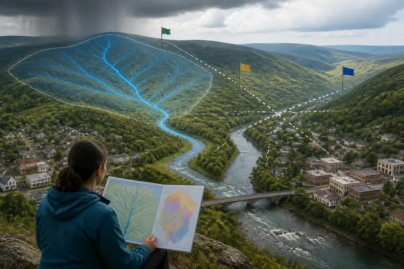
A rainstorm falls on a hillside outside a town, then its runoff joins a creek that crosses a county line and eventually reaches another country. A political map may show the jurisdictions the water passes through; a watershed map traces where the water itself goes. Comparing river basin and political border maps reveals two different kinds of connection—and helps you choose which one answers a question about shared resources.
Each map draws a different kind of line
A political boundary map represents areas governed by different authorities: countries, states, provinces, counties, or municipalities. Its lines show where jurisdiction changes. Depending on the map, colors or labels may distinguish those areas, while rivers appear as features within or between them.
A watershed map, also called a drainage-basin map, organizes land according to where water flows. A watershed is the land that drains toward a common outlet, such as a stream, lake, or estuary. Its outer edge is a drainage divide: a ridge or other high ground that separates runoff flowing into different basins.
The two kinds of boundary can overlap, but neither defines the other. A watershed can cross several political jurisdictions, and a political territory can contain parts of several watersheds. A river may serve as a border in one stretch, yet flow through the interior of a jurisdiction elsewhere.
A watershed follows the flow of water
To read a watershed map, begin at the outlet and work upstream. Smaller tributaries join larger streams, which carry water toward that outlet. The basin boundary generally follows higher ground around this network, although the map’s level of detail affects how clearly small drainage areas appear.
This view makes upstream and downstream relationships visible. Rain, snowmelt, and water carried over land can move from one community to another without regard for a jurisdiction’s border. A watershed map therefore helps frame questions about where water comes from, which tributaries feed a river, and what areas drain toward a particular lake or estuary.
It also has limits. A basin boundary does not show who has legal authority over water, which communities use it, or how a resource is managed. Nor does every watershed map depict the same scale: a broad basin map may group smaller catchments that a local map shows separately.
A political map follows authority and responsibility
Political maps are useful when the subject involves decisions made by governments or the areas those decisions cover. They can help identify which jurisdictions border a river, where an administrative responsibility begins, or which local government contains a particular community.
Those boundaries matter because rules and institutions are organized geographically. But a political map can make a connected river system look divided into separate areas. It may show the locations of jurisdictions without showing how water moves between them, or how an action upstream could affect people downstream.
Political boundaries can also be nested. A place may belong to a municipality, a county, and a state or province at the same time. If a question concerns responsibility, the relevant level is not always the largest one on the map; it depends on the decision or service being discussed.
Choose the map that matches the question
Before choosing a map, name the relationship you want to understand. If the question is about water moving across land, start with the watershed. If it is about jurisdiction, representation, or the reach of a public decision, start with political boundaries. For many subjects, looking at both is more informative than treating either as a complete account.
- Where does runoff from this hillside go? Use a watershed map to follow drainage toward a stream or basin outlet.
- Which communities sit upstream or downstream? Use a watershed map to trace the river network, then add a political map to identify the jurisdictions those communities occupy.
- Which government area contains this site? Use a political map, checking whether the question concerns a municipality, county, state, province, or country.
- Who may need to coordinate across a shared river? Compare the basin boundary with political boundaries to see where the water system and governing areas intersect.
- Does a map omit an important connection? Check its scale, legend, date, and displayed boundaries; then compare it with the other map type if the question spans both water flow and authority.
Imagine a reader is trying to understand why two towns discuss a river together even though they sit in different counties. A political map shows the county line and locates each town; a watershed map shows that both drain toward the same river system. The combined view explains why the towns may share a water-related concern, while leaving questions of legal responsibility for a closer look at the relevant governments and rules.
What can these two maps tell you together?
Can a watershed cross a country or state line?
Yes. Water follows the land’s drainage pattern, not the jurisdictional boundary. A basin map can show the shared physical system, while a political map identifies the countries, states, or provinces within it.
Does a river always form a political border?
No. A river may mark a boundary in some places and pass through the interior of a jurisdiction in others. The political map shows whether a boundary is represented there; the watershed map shows the river’s wider drainage connections.
Which map should I use for a question about water quality?
A watershed map helps identify the land and streams draining toward the waterbody in question. A political map can then locate jurisdictions that may have relevant responsibilities, though a map alone cannot establish what rules apply.
Why do watershed maps at different scales look different?
Maps simplify features to suit their scale and purpose. A regional map may show a large basin clearly while leaving small streams or local divides out; a more detailed map can show smaller drainage areas.
Read the map’s edges as carefully as its center
Map legends and labels explain what the lines represent, but the map’s scope matters too. Look for its scale, the area covered, and whether it shows the full basin or only a selected section. A map that ends at a national boundary may make a river appear to stop there even when the watershed continues beyond the frame.
Also distinguish a watershed boundary from the river channel. The channel is the route water follows in a stream or river; the watershed boundary encloses the land draining toward an outlet. Confusing these can make a basin map seem like a map of the river alone, when its central information is the relationship between the river and surrounding land.
Mapmakers may use different names for related drainage areas, and some maps display nested sub-basins rather than a single large basin. Read the legend and source notes before comparing boundaries, especially when two maps appear to disagree. Their differences may reflect scale or classification rather than a change in the physical flow of water.
Keep both stories in view
River basin and political border maps answer different questions because they organize place around different relationships. The first follows water across land; the second locates areas of authority. For a question about shared rivers, the clearest starting point is often the watershed map, paired with political boundaries when you need to understand where communities and responsibilities sit.
When you encounter a map in a report or classroom, ask what its lines include and what they leave outside the frame. That simple check can prevent a connected basin from being mistaken for a set of isolated jurisdictions—or a physical drainage pattern from being mistaken for a map of who governs it.